
New Snow and Ice Warning for Friday and Saturday: What You Need to Know
“UK Braces for Disruption as Snow and Ice Threaten Travel, Schools, and Daily Life This Weekend”

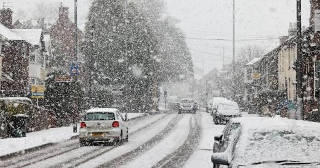
The UK is bracing for another round of disruptive winter weather as meteorologists issue fresh snow and ice warnings for Friday and Saturday. Across England, Scotland, and Wales, residents are being advised to prepare for hazardous conditions, with local authorities urging people to limit travel and stay safe. The latest forecasts indicate a combination of heavy snowfall, freezing temperatures, and icy patches, all of which could affect daily routines, public transport, and emergency services.
The Details of the Warning
According to the Met Office, the new weather alert covers large parts of the UK, with particular emphasis on northern England, central Scotland, and higher-altitude areas in Wales. Snow is expected to fall intermittently, accompanied by gusty winds that may reduce visibility and make roads treacherous. Night-time temperatures are predicted to drop well below freezing, increasing the risk of ice forming on roads, pavements, and public walkways.
The official warning highlights:
Friday: Snow showers beginning in the morning, gradually intensifying in the afternoon, with temperatures hovering around -2°C in many northern regions.
Friday Night into Saturday: Freezing conditions combined with residual snow and sleet, causing black ice and slippery surfaces.
Saturday: Continued snow in certain areas, particularly in Scotland and upland Wales, with accumulations of 5–10 cm expected in higher regions.
Weather experts are emphasizing the danger posed by black ice, which can be difficult to detect and significantly increases the likelihood of accidents on roads and footpaths.
Impact on Travel and Transportation
The snow and ice warnings are likely to cause disruptions to both local and national transport. Rail services may experience delays or cancellations due to frozen tracks or icy platforms. Motorists are warned to drive cautiously and to allow extra time for journeys, as untreated roads and poor visibility create hazardous conditions. Public transport providers have announced contingency measures, including reduced service schedules and additional safety checks.
Airports are also on alert. While the Met Office does not expect widespread flight cancellations at this stage, passengers are advised to check with their airlines before traveling, as snow and ice can delay departures and arrivals.
Safety Measures for Residents
Authorities are urging residents to take precautions to protect themselves and their property. The following tips are recommended:
Travel: Avoid unnecessary journeys, and if travel is essential, keep an emergency kit in your vehicle, including blankets, food, water, and a charged mobile phone.
Footwear: Wear appropriate shoes with good grip to prevent slips and falls on icy surfaces.
Home Preparedness: Check heating systems, insulate pipes to prevent freezing, and ensure adequate supplies of food and medication.
Community Care: Look out for vulnerable neighbors, particularly the elderly or those with mobility issues, who may be at higher risk in icy conditions.
Local councils are preparing gritters and salt spreaders to treat high-risk roads, while emergency services are on standby for potential incidents.
The Science Behind the Winter Blast
Meteorologists explain that the current snow and ice warning is due to a cold Arctic air mass moving southward across the UK. This brings below-average temperatures and creates conditions favorable for snowfall. Combined with overnight frost and residual moisture from earlier precipitation, the risk of ice formation is high.
Professor Helen Davies, a climate scientist, notes, “While snowfalls may appear modest in isolation, the combination of freezing temperatures and wind chill amplifies their impact. Even light snow can turn dangerous when it forms ice overnight, affecting travel and public safety.”
Historical Context and Public Preparedness
Winter storms have long disrupted life in the UK, with past events prompting large-scale school closures, travel delays, and emergency alerts. Residents have become more accustomed to planning ahead, with mobile alerts and social media providing timely updates. Despite modern infrastructure, snow and ice continue to test the resilience of local authorities and the public.
Looking Ahead
The Met Office predicts that the snow and ice conditions could persist into the weekend, particularly in northern and elevated regions. Temperatures are expected to remain low, meaning the risk of icy surfaces will continue even after snow has stopped falling. Experts advise people to remain vigilant and follow official guidance to avoid accidents or injury.
While winter weather brings challenges, it also offers opportunities for communities to come together, whether by helping neighbors clear pathways or preparing schools and businesses for safe operation. Awareness and preparedness remain the best tools to mitigate the impact of snow and ice.
Conclusion
With the new snow and ice warning for Friday and Saturday, the UK faces a significant winter weather event that could disrupt travel, daily life, and safety. Authorities and residents are urged to exercise caution, follow official guidance, and plan ahead. From treating roads to ensuring home preparedness, taking proactive steps can make the difference between inconvenience and serious accidents.
As winter continues to challenge the UK, vigilance, preparation, and community spirit will be key to navigating the hazards posed by snow and ice. For now, staying informed and staying safe remain the top priorities as the cold snap approaches.
About the Creator
Fiaz Ahmed
I am Fiaz Ahmed. I am a passionate writer. I love covering trending topics and breaking news. With a sharp eye for what’s happening around the world, and crafts timely and engaging stories that keep readers informed and updated.
Keep reading
More stories from Fiaz Ahmed and writers in Earth and other communities.
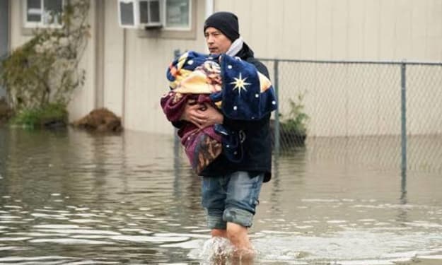
Flooding Remains Threat in Pacific Northwest as Washington Declares Emergency
The Pacific Northwest is facing a continuing climate crisis as devastating floods threaten communities across Washington State. Following days of unprecedented rainfall and rising river levels, Governor Jay Inslee declared a state of emergency, mobilizing emergency services and urging residents to remain vigilant as the region braces for further inundation.
By Fiaz Ahmed 2 months ago in Earth


Comments
There are no comments for this story
Be the first to respond and start the conversation.