
Mobile Mapping Market Insights: Autonomous Vehicles, 3D Data & Industry Forecast to 2033
How autonomous vehicles and ADAS advancements are driving demand for mobile mapping solutions, delivering detailed 3D road data, lane detection, and environment modeling for safer navigation.

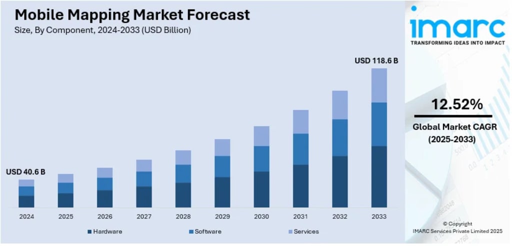
The evolution of location-based technology and growing infrastructure needs are reshaping how we map our world. According to IMARC Group's latest analysis, the global mobile mapping market size was valued at USD 40.6 Billion in 2024. Looking forward, IMARC Group estimates the market to reach USD 118.6 Billion by 2033, exhibiting a CAGR of 12.52% from 2025-2033.
Mobile mapping has become essential for modern geospatial applications, transforming industries from urban planning to autonomous vehicles. The technology enables real-time collection of precise three-dimensional spatial data through sensors mounted on vehicles, drones, and portable devices. As cities become smarter and infrastructure demands intensify, the need for accurate, up-to-date geospatial information is reaching unprecedented levels. Between 2013 and 2022, the United States alone saw 4,633 AI startups emerge, with 524 founded in 2022, attracting USD 47 billion in non-governmental funding. This innovation ecosystem is directly fueling advanced mobile mapping solutions with AI-powered data acquisition and real-time analytics capabilities.
Mobile Mapping Market Growth Drivers:
- Smart City Development and Infrastructure Modernization
Approximately 39 percent of global mobile mapping deployments stem from smart city infrastructure initiatives. The U.S. Department of Transportation invested over USD 2.1 billion through its Smart City Challenge to encourage cities to use digital mapping technologies for urban development. India's Smart Cities Mission aims to develop 100 smart cities, with over 500 smart city projects being developed across Asia Pacific, and China alone accounting for more than 300 initiatives. These projects require precise geospatial data for traffic management, utility optimization, and public safety systems. Mobile mapping enables governments to create digital twins of entire urban areas, facilitating better resource management and planning decisions that improve quality of life for residents.
- Autonomous Vehicle Revolution and HD Mapping Requirements
The autonomous vehicle sector is creating unprecedented demand for high-definition maps with centimeter-level accuracy. Over 50 companies are actively testing self-driving vehicles globally, each requiring continuously updated mapping data for navigation, obstacle detection, and route optimization. In the United States, approximately 36 percent of global mobile mapping deployments support autonomous vehicle development, with over 21,000 vehicles and 5,400 drones in active mapping operations. These HD maps must include detailed information about lane markings, road furniture, elevation changes, and traffic infrastructure data that traditional mapping cannot provide.
- Widespread Smartphone Adoption and IoT Integration
With 6.8 billion smartphone users globally and 5G coverage reaching 60 percent of the world's population in 2023, mobile mapping has gained unprecedented accessibility. Smartphone penetration in Asia Pacific is expected to reach 83 percent by 2025, up from 68 percent in 2020. The number of connected IoT devices in logistics reached 13.8 billion in 2024, up from 9.9 billion in 2020. This explosion in connected devices creates massive demand for location-based services across retail, transportation, and tourism. Companies like Amazon, UPS, DHL, FedEx, and Maersk now leverage mobile mapping for real-time tracking, route optimization, and asset management, dramatically improving operational efficiency and customer experience.
Mobile Mapping Market Trends:
- AI-Powered Data Processing and Generative AI Integration
Generative AI is transforming mobile mapping by automating point cloud classification, feature extraction, and anomaly detection from massive geospatial datasets, significantly reducing processing times. AI-driven features in mapping applications have improved route accuracy by 30 percent and reduced estimated time of arrival errors by 25 percent. In 2025, generative AI models enable real-time map updates and provide context-aware navigation assistance by predicting road conditions and hazards. This technology synthesizes and interprets complex mapping data, enhancing both precision and decision-making speed. The use of AI in logistics is expected to grow at a rate of 17.2 percent annually through 2028, making mobile mapping systems more responsive and reliable than ever before.
- Drone-Based Mapping and Multi-Platform Integration
Drone-mounted mobile mapping platforms grew by approximately 34 percent year-over-year in 2025, enabling flexible aerial 3D scanning without road-based access limitations. These systems now account for 33 percent of mounting types in the market, opening vertical mines, cliff faces, and disaster zones to rapid LiDAR coverage. Lighter solid-state sensors have extended flight endurance while onboard AI filters vegetation in real time, reducing downstream workload. The integration of multiple platforms vehicles, drones, railway trolleys, and backpack units—creates a diversified equipment mix that addresses everything from highway corridors to confined indoor spaces.
- 5G Connectivity and Real-Time Mapping Capabilities
The rollout of 5G networks is revolutionizing mobile mapping with faster data transfer speeds and real-time geospatial analytics. Saudi Arabia leads the Middle East and Africa region with more than 11.2 million 5G subscriptions by the end of 2022, accounting for over a quarter of its total mobile sector. South Korea recorded 31.3 million 5G connections in 2021, representing more than 48 percent of all mobile connections, while China accounts for more than 700 million connections. This widespread 5G adoption enables instantaneous transmission of high-resolution mapping data, supporting applications in autonomous vehicles, smart city monitoring, and emergency response systems. The U.S. Infrastructure Investment and Jobs Act allocated approximately USD 45 billion for broadband expansion, further enhancing mobile mapping capabilities across underserved areas.
Recent News and Developments in Mobile Mapping Market
- July 2024: GeoCue Corporation released TrueView GO, a handheld geospatial solution available in 116S (16-channel) and 132S (32-channel) models. The system integrates GNSS RTK, LiDAR, cameras, and visual SLAM to create real-time digital twins for indoor and outdoor applications, significantly expanding accessibility for field professionals who need rapid, accurate spatial data collection.
- June 2024: Growing Mid Wales (GMW) launched a mobile mapping project in collaboration with waste collection vehicles and major mobile network operators to identify areas in Powys and Ceredigion with poor mobile coverage. Funded by the UK Shared Prosperity Fund, this initiative demonstrates how mobile mapping extends beyond traditional surveying to address connectivity challenges in rural communities.
- March 2024: Trimble introduced the MX90 mobile mapping system, combining GNSS, inertial technology, and Trimble's proprietary software in an all-in-one solution. Designed for vehicle or train mounting, the MX90 can map at highway speeds, gathering detailed laser scans and high-resolution imagery with efficient data-processing capabilities for crack detection and asset inspections.
Note: If you require specific details, data, or insights that are not currently included in the scope of this report, we are happy to accommodate your request. As part of our customization service, we will gather and provide the additional information you need, tailored to your specific requirements. Please let us know your exact needs, and we will ensure the report is updated accordingly to meet your expectations.
About the Creator
Andrew Sullivan
Hello, I’m Andrew Sullivan. I have over 9+ years of experience as a market research specialist.
Keep reading
More stories from Andrew Sullivan and writers in Futurism and other communities.
Wi-Fi Chipset Market Outlook: Smart Devices, Edge Computing & Industry Forecast to 2033
The surge in connected devices, rapid IoT expansion, and growing demand for high-speed wireless connectivity are propelling the Wi-Fi chipset market, driven by advancements in Wi-Fi 6, 6E, and 7 technologies alongside accelerating deployment of smart home devices and enterprise networking solutions. According to IMARC Group's latest data, the global Wi-Fi chipset market size was valued at USD 20.5 Billion in 2024. Looking forward, IMARC Group estimates the market to reach USD 26.5 Billion by 2033, exhibiting a CAGR of 2.74% from 2025-2033.
By Andrew Sullivan3 days ago in Futurism
How Long-Term Forecasts are Formed in the Cryptocurrency Market?
The cryptocurrency market has matured into a complex financial environment where long-term forecasting requires more than short-term price trends. Early market behavior was often driven by speculation and hype, but today’s digital asset ecosystem is shaped by infrastructure development, real-world adoption, regulatory clarity, and macroeconomic conditions.
By Muhammad Irfan Afzala day ago in Futurism
Egypt Courier, Express, and Parcel (Cep) Market Analysis: Industry Overview, Key Players & Growth Outlook
According to IMARC Group's latest research publication, the Egypt courier, express, and parcel (CEP) market size reached USD 1,694.1 Million in 2025. The market is projected to reach USD 2,837.4 Million by 2034, exhibiting a growth rate (CAGR) of 5.60% during 2026-2034.
By Abhay Rajput5 days ago in Futurism


Comments
There are no comments for this story
Be the first to respond and start the conversation.