
N.J. Weather: Up to 2 Feet of Snow, Dangerous Blizzard Conditions in Updated Forecast for Monster Storm
Meteorologists warn of life-threatening travel conditions, heavy snowfall rates, and widespread disruptions as a powerful winter storm barrels toward New Jersey.
New Jersey is bracing for what forecasters are calling a potential “monster” winter storm — one that could bury parts of the state under as much as two feet of snow while unleashing blizzard conditions that threaten to paralyze travel and daily life.
Updated forecasts show rapidly intensifying snowfall totals, with heavy bands expected to stall over northern and central portions of the state. Wind gusts exceeding 40 to 50 mph could combine with intense snowfall rates to produce whiteout conditions, making roads nearly impassable at the height of the storm.
The combination of deep snow accumulation and strong winds has prompted warnings of dangerous conditions across much of the Garden State.
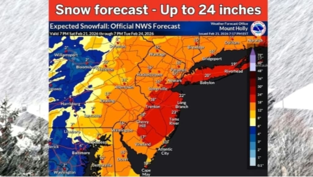
How Much Snow Could Fall?
Meteorologists now project snowfall totals ranging from 12 to 24 inches in many communities, with localized amounts potentially exceeding two feet in higher elevations and areas where heavy snow bands linger the longest.
The greatest impact is expected across northern New Jersey, including counties along the Interstate 80 corridor and into the suburbs surrounding New York City. Central New Jersey is also forecast to receive significant accumulation, while southern coastal regions may initially see a mix of rain and snow before colder air takes hold.
Snowfall rates could exceed 1 to 3 inches per hour during peak intensity, overwhelming plowing operations and quickly covering treated roadways.
Blizzard Conditions a Major Concern
The updated forecast highlights not just heavy snow, but also blizzard-level impacts. Sustained winds of 25 to 35 mph, paired with powerful gusts, could produce near-zero visibility at times.
Under official criteria, blizzard conditions occur when visibility drops below a quarter mile due to blowing snow for at least three consecutive hours. Forecasters warn that these conditions are possible — especially during the storm’s most intense overnight phase.
Whiteout conditions pose a significant threat to motorists. Even short trips could become hazardous or impossible once snowfall rates and wind speeds increase.
Emergency management officials are urging residents to avoid unnecessary travel once conditions deteriorate.
Timing of the Storm
The system is expected to begin as light snow before intensifying rapidly. Forecasters say the storm will strengthen as it moves up the East Coast, tapping into Atlantic moisture while colliding with cold Arctic air.
The heaviest snowfall is projected during a 12- to 18-hour window when the storm reaches peak intensity. That period could bring the worst travel conditions and the highest risk of power outages.
By the time the system exits, lingering snow showers and strong winds may continue to create drifting snow and reduced visibility even after the main accumulation ends.
Power Outages and Infrastructure Strain
Heavy, wind-driven snow places added stress on power lines and tree branches. If snowfall becomes wet and dense — especially in areas closer to the coast — the weight could increase the risk of downed lines.
Wind gusts above 40 mph will compound the danger, potentially snapping weakened limbs and causing scattered outages. Utility crews are reportedly preparing for rapid response, but restoration efforts may be slowed by dangerous road conditions.
Air travel is also expected to be heavily disrupted. Major airports serving the region could see delays and cancellations as airlines proactively ground flights.
Coastal Concerns
While snow is the primary threat inland, coastal communities face additional risks. Strong onshore winds could generate minor coastal flooding during high tide cycles. Beach erosion and rough surf are also possible.
For shore towns, the storm’s exact track will determine whether snowfall totals reach the higher end of projections or if periods of sleet and rain mix in before colder air fully dominates.
Why This Storm Is So Powerful
Meteorologists point to a rapidly intensifying low-pressure system — sometimes referred to as “bombogenesis” — as the driving force behind this event. When atmospheric pressure drops sharply within 24 hours, storms can strengthen quickly, leading to extreme precipitation and high winds.
The interaction between Arctic air plunging southward and moist air from the Atlantic Ocean creates ideal conditions for heavy snow production.
Forecast models show a tightly wound system capable of producing intense snow bands. In such setups, slight shifts in track can dramatically alter snowfall totals from one town to the next.
Preparing for Impact
Officials are urging residents to take the storm seriously and prepare accordingly:
Stock up on essential supplies, including food, water, and medications
Charge electronic devices in case of power outages
Have flashlights and batteries readily available
Avoid travel during peak storm hours
Check on elderly neighbors and vulnerable individuals
Drivers who must travel should carry emergency kits that include blankets, water, non-perishable snacks, and a fully charged phone.
Snow removal operations will likely begin early, but heavy rates may outpace plows during the height of the storm.
Schools and Business Closures Likely
Given the projected severity, widespread school closures and delayed openings are expected. Many businesses may also close or shift to remote operations, particularly if blizzard warnings are issued.
Government offices could scale back services, and public transportation may operate on limited schedules or suspend service during peak conditions.
The Bigger Picture
Major snowstorms are not uncommon in New Jersey, but a two-foot snowfall event combined with blizzard conditions remains significant. Such storms can disrupt economic activity for days and leave behind challenging cleanup efforts.
Climate variability continues to influence winter weather patterns, sometimes producing more intense precipitation events even as average winter temperatures fluctuate. In this case, ample cold air is firmly in place — allowing the storm to maximize snowfall potential.
What Happens After the Storm
Once skies clear, residents may face frigid temperatures that could cause snow to freeze solid, complicating removal efforts. Refreezing overnight can create dangerous icy patches on untreated roads and sidewalks.
Plow crews may require several days to fully clear secondary streets, particularly if drifting becomes severe.
Despite the challenges, many residents view major snowstorms as part of New Jersey’s winter identity. Yet officials stress that this system should not be underestimated.
With forecasts calling for up to two feet of snow, powerful winds, and possible blizzard conditions, preparation and caution will be critical.
As meteorologists continue refining snowfall projections and storm timing, one message remains consistent: this is a high-impact winter event with the potential to bring dangerous, even life-threatening conditions across the state.
Residents are urged to monitor updates closely and take action before conditions worsen
About the Creator
A Gathering of Evil Bosses
“I’m the queen of chin jutting while I smooth my hair, attacking, insulting, and deflecting to protect my appointer.” “Oh, please, Blondi, my hair is curled, highlighted, and longer than yours. I feature television commercials telling immigrants that we will give them a free plane ride home, and if they voluntarily turn themselves in, they will be allowed to legally apply for re-entry. It runs everywhere, and I look good in it! You can’t compete because of your blond hair. Mine is nicer, and my lips are prettier than yours.”
By Andrea Corwin 4 days ago in The Swamp


Comments
There are no comments for this story
Be the first to respond and start the conversation.