
UPDATE: Flood Watch Extended Through Tonight for Kaua‘i, Ni‘ihau as Unstable Weather Conditions Persist
Forecasters warn of heavy rainfall, flash flooding, and hazardous travel as saturated grounds heighten risk across the western Hawaiian Islands.
A flood watch has been extended through tonight for Kaua‘i and Ni‘ihau as unstable atmospheric conditions continue to fuel heavy rainfall across the western end of the Hawaiian Islands. Meteorologists say persistent showers, combined with already saturated soils, could quickly lead to flash flooding in low-lying areas, streams, and flood-prone roadways.
The extended watch signals ongoing concern that repeated downpours may overwhelm drainage systems and cause water levels in rivers and gulches to rise rapidly.
Why the Flood Watch Was Extended
Forecasters point to lingering instability in the atmosphere and deep tropical moisture lingering over the region. Upper-level disturbances interacting with warm ocean air have created an environment conducive to intense rainfall bursts.
While rainfall intensity may vary from neighborhood to neighborhood, localized heavy showers are expected to continue through the evening hours. Slow-moving storm cells could repeatedly track over the same areas — a phenomenon known as “training” — increasing the risk of flash flooding.
The threat is amplified by saturated ground conditions from earlier rainfall. When soil can no longer absorb additional moisture, runoff increases quickly, sending water into streams and urban areas.
Areas of Greatest Concern
Low-lying neighborhoods, stream beds, and areas near steep terrain are particularly vulnerable. Kaua‘i’s mountainous interior funnels rainwater downslope, often leading to rapid rises in creeks and rivers after heavy showers.
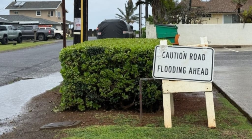
Roadways prone to ponding water may become hazardous, especially after dark when visibility is reduced. Motorists are being urged to avoid driving through flooded roads, as even shallow water can stall vehicles or hide deeper hazards beneath the surface.
Ni‘ihau, though sparsely populated, faces similar risks due to its exposure to passing rain bands and limited drainage infrastructure.
Potential Impacts
If rainfall intensifies or persists longer than expected, impacts could include:
Flash flooding in urban and rural areas
Overflowing streams and drainage channels
Landslides or falling debris in steep terrain
Temporary road closures
Power interruptions in isolated areas
Residents are advised to monitor water levels in nearby streams and remain alert for rapidly changing conditions. Flash flooding can develop quickly with little warning, particularly during periods of heavy rainfall.
Travel and Safety Concerns
Driving conditions may deteriorate rapidly during downpours. Reduced visibility, hydroplaning risks, and debris on roadways can all contribute to dangerous travel.
Emergency officials recommend delaying non-essential travel during periods of heavy rain. If you encounter a flooded roadway, turn around rather than attempting to cross. Floodwaters can be deceptively strong and may conceal washed-out pavement or obstacles.
Those living near flood-prone areas should have emergency plans in place and be prepared to move to higher ground if conditions worsen.
Why Kaua‘i Is Especially Vulnerable
Kaua‘i’s topography makes it particularly susceptible to heavy rainfall events. Known as the “Garden Isle,” it features steep mountain ridges and deep valleys that can channel large volumes of water quickly toward coastal communities.
When tropical moisture interacts with local terrain, rainfall can become intense and localized. Some areas may receive significantly more precipitation than neighboring communities just a few miles away.
This variability makes forecasting challenging, as pinpointing exact rainfall totals for specific neighborhoods is difficult during unstable weather patterns.
The Role of Unstable Weather Patterns
Meteorologists describe the current setup as unstable due to a combination of upper-level disturbances and abundant low-level moisture. These ingredients allow clouds to grow vertically, producing heavier rainfall than typical passing showers.
Warm ocean waters surrounding the islands provide continuous moisture, sustaining rain bands as they move across the region.
While the system is not classified as a tropical storm, its moisture-rich environment can still produce rainfall rates capable of triggering flash floods.
Preparedness Tips for Residents
Authorities encourage residents to take proactive steps to protect themselves and their property:
Clear gutters and storm drains near your home
Secure outdoor items that could be swept away
Keep emergency supplies, including water and flashlights, readily available
Stay informed through local weather updates and alerts
Identify higher ground locations in case evacuation becomes necessary
Community members are also encouraged to check on elderly neighbors or those with limited mobility, ensuring they have access to assistance if needed.
What to Expect Overnight
The flood watch remains in effect through tonight as forecasters monitor rainfall trends. If heavy showers persist into the overnight hours, the risk of flash flooding may continue, particularly in areas that receive repeated rainfall bursts.
Should rainfall intensify further, a flood warning could be issued for specific locations. A watch indicates conditions are favorable for flooding, while a warning means flooding is imminent or already occurring.
Residents are urged to keep mobile devices charged and enable emergency alerts in case conditions escalate quickly.
Looking Ahead
Weather models suggest gradual improvement may occur once the unstable pattern shifts or weakens. However, uncertainty remains regarding how quickly moisture will exit the region.
Even after rainfall diminishes, swollen streams may take time to recede, and muddy or debris-covered roads could pose hazards.
Officials emphasize that conditions can change rapidly in Hawaii’s microclimates. Continuous monitoring will be essential through the night.
Community Vigilance Remains Key
Flooding is one of the most dangerous weather hazards in Hawaii, often developing faster than residents expect. With unstable conditions persisting over Kaua‘i and Ni‘ihau, the extended flood watch serves as a reminder to remain cautious and prepared.
Though not every community will experience severe flooding, the potential exists for localized impacts that could disrupt travel and daily routines.
As the evening progresses, residents should stay alert, avoid complacency, and prioritize safety until the threat fully subsides.
With heavy rain still in the forecast and soils already saturated, preparedness and awareness will be critical in minimizing risks during this period of unsettled weather.
About the Creator
Winter Storm Warning Issued as Up to 60 Inches of Snow Expected This Weekend
Authorities across multiple regions of the United States have issued winter storm warnings as a powerful weather system is forecasted to bring up to 60 inches of snow over the weekend. Officials are urging residents to prepare for major travel disruptions, power outages, and potentially life-threatening conditions. Emergency services are mobilizing in anticipation of the storm, which meteorologists describe as “historic” in its intensity. Scope of the Storm The storm system, originating in the northern Rockies and moving eastward, is expected to impact several states, including Colorado, Wyoming, Nebraska, and parts of the Midwest. Snowfall rates could exceed 4 to 6 inches per hour in certain areas, with blizzard conditions likely near higher elevations. According to the National Weather Service (NWS), the storm’s combination of heavy snow, strong winds, and low temperatures is expected to create hazardous travel conditions, including zero visibility and drifting snow that can block roadways. Travel and Transportation Impacts Airports in affected regions have already announced delays and cancellations. Major highways and interstates are expected to be treacherous or temporarily closed. The Department of Transportation has advised motorists to avoid non-essential travel and warned that emergency services may be delayed due to road conditions. “Drivers need to prepare for rapidly changing conditions,” said a spokesperson for the NWS. “Even short trips could become extremely dangerous. Snow accumulation and icy roads will significantly impair visibility and vehicle control.” Public transportation services, including rail and bus systems, may also experience interruptions. Commuters are encouraged to check with local transit authorities before traveling and to consider remote work arrangements where possible. Power Outages and Safety Concerns Heavy snow and strong winds are expected to weigh down trees and power lines, potentially causing widespread power outages. Utility companies in the region are pre-positioning crews and equipment to respond quickly, but officials warn that restoration could take several days in some rural or heavily impacted areas. Residents are advised to stock up on essential supplies, including food, water, and medications. Heating systems should be checked, and alternative sources of warmth prepared in case of prolonged outages. Carbon monoxide safety is emphasized for those using generators or alternative heating devices indoors. Emergency Services and Preparedness Local governments have activated emergency operation centers, with shelters prepared for residents stranded or displaced by the storm. Emergency responders recommend that residents create family emergency plans and maintain communication with neighbors, particularly the elderly or those with limited mobility. Schools and universities in affected areas are announcing closures or delays. Authorities warn that even after the storm passes, travel may remain hazardous due to accumulated snow, ice, and debris. Meteorological Significance Meteorologists note that this winter storm is unusually intense for this period, with snowfall totals rivaling previous historic events in the northern Rockies and Midwest. Forecasters emphasize that such storms are becoming more frequent and severe, raising broader concerns about infrastructure resilience and climate patterns affecting winter weather extremes. “The sheer volume of snow expected this weekend is extraordinary,” said a senior meteorologist. “Communities must act now to mitigate risks and stay safe throughout the event.” Looking Ahead Residents are advised to stay tuned to weather updates via local media and official channels. The NWS will continue to issue hourly updates and warnings as the storm progresses. Officials emphasize that preparation, caution, and awareness are key to minimizing risk and protecting lives during the extreme weather event. As snowfall accumulates and conditions deteriorate, authorities are reminding everyone that staying indoors and avoiding travel unless absolutely necessary is the safest course of action.
By Fiaz Ahmed a day ago in Earth


Comments
There are no comments for this story
Be the first to respond and start the conversation.